The European Space Agency’s venerable Envisat satellite may have sent back its final image, according to recent news from the Agency.
On April 8, ESA lost communication with the Earth-observation satellite, preventing reception of data as it passed over the Kiruna station in Sweden. Although it’s been confirmed that the satellite is still in orbit, the recovery team has not been able to re-establish contact.
The image above, showing part of the Iberian peninsula, was from the last data to be received from Envisat before it fell silent.
Launched in March 2002, Envisat has been helping researchers examine our planet for over ten years — five years longer than its original mission duration. It has completed more than 50,000 orbits and returned thousands of images, as well as a wealth of data about the land, oceans and atmosphere.
Envisat data was instrumental in over 4,000 projects from 70 countries.
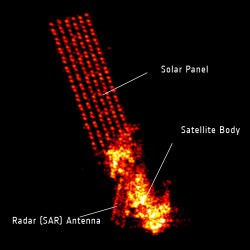
Germany’s Tracking and Imaging Radar captured an image of the satellite, revealing that it is still intact and in a stable orbit. Still, all attempts at recovery have so far been unsuccessful.
A contingency agreement with the Canadian Space Agency on Radarsat will be activated to fulfill user requirements if Envisat cannot be brought back online.
Source: Universe Today


No hay comentarios:
Publicar un comentario